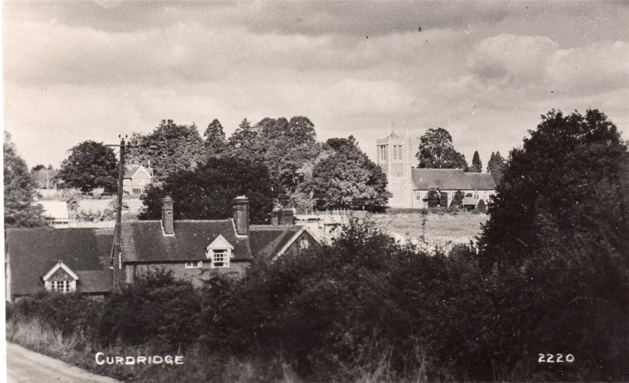
A series of articles written for the Curdridge Parish Magazine.
With the arrival of the modern Land Registry, old title deeds have become superfluous and are often simply thrown away when properties come to be sold. Fortunately, our solicitor saved the deeds for us when we moved into Tanglewood and I spent several weeks’ worth of winter evenings trying to unravel the history of the house and its land.
The older papers ‑ the earliest dated 5th July 1853 ‑ are beautifully handwritten documents on thick waxed paper with elaborately scripted titles. Two are written on printed engrossment paper and are sealed at the bottom with wax. From 1925, however, the papers are typed and full of errors and obvious failures to understand what was being copied. The art and experience of the legal clerk had gone.
Among the documents is an “Abstract of Title”, dated 6th August 1883. It begins with a summary of the Will of the 15th March 1862 of one William Camper, concerning, “All those two cottages and premises then lately erected and built by him … with the land and farm buildings thereon and adjoining thereto”. The original building was it seems a pair of two up two down “cottages”, both since substantially extended, one of which, has now become Tanglewood.
“William Camper of Gosport in the parish of Alverstoke in the County of Southampton, Shipbuilder” was one of the founders of the now world-famous yacht-builders firm of Camper and Nicholsons, still based in Gosport. In 1809 the young William Camper was apprenticed for a period of seven years to Francis Amos, a former ferry‑man between Gosport and Portsmouth who had turned to boat building near the ferry steps in 1783. At the age of about thirty‑five Camper took over the shipyard, presumably on the death of Amos, and in the following years built up with his partner Benjamin Nicholson, such a profitable business that he not only became wealthy but also earned himself the status of “Gentry” in the local Post Office Directory.
He seems to have bought the plot of land which has now become Tanglewood in about 1857 and he must have had the cottages built sometime between then and March 1862, the date of his Will. He also seems to have had built a couple of other properties nearby, further along the lane, including a modest Victorian villa which is still called “Camper House”.
When William Camper died in 1863 the land and cottages went to his daughter Mary. Unfortunately, things then appear not to have gone well. Between 1872 and 1883, when Mary died, “various dealings” with a number of individuals resulted in the ownership of the property being divided into three shares, two owned by two of Mary’s four sons and one by a Henry Morton Cotton. It looks as though the other two brothers, and possibly Mary’s second husband, John Earl, had used their shares to raise loans which they failed to repay.
Given this situation the two remaining brothers presumably had no choice but to sell the property. It was sold on the 6th August 1883 to Robert Anthony Burrell of Fairthorne and Augusta Burrell, Spinster, his sister, for the sum of £850.
The Burrells were from a wealthy mine‑owning family from Durham and had come down in 1878 and bought the 120 acre Fairthorne Estate, one boundary of which lay adjacent or close to Camper’s land. There is no record of what they did with the cottages and land but it may have been used to house some of the estate staff. Other houses nearby were especially built by Augusta Burrell for this purpose.
Robert Burrell died in 1910 and his sister, after a long life of local philanthropy, died in 1924. In 1925 the Fairthorne estate was sold by Augusta Burrell’s executors. What had been Camper’s cottages and land was sold to one George William Jupe, Farmer, on the 16th September of that year, for the sum of £1,250. In fact, George Jupe had already been occupying the cottage and land since the 1900’s. This is not stated in the documents, but Alf Mears, who was born in one of the Fairthorne staff cottages in 1912 and then lived in another, told me that it was certainly the case. At one time, said Mr Mears, Jupe courted his Aunt, but nothing came of it and Jupe remained a bachelor. He lived in the cottage with a housekeeper, who kept a small shop in the front room, and her daughter.
What Mr Mears did not know, but the documents reveal, is that in order to buy the property Mr Jupe had borrowed a substantial sum of money. On the day after the sale he mortgaged the entire property to one Allan Bowes Wilson of Hutton Rudby, Yorks, for £1000. Wilson was clearly a relative ‑ perhaps the father or brother ‑ of Augusta Burrell’s solictor John George Wilson of the Durham firm of Wilson, Ornsby and Cadle. Unfortunately, it seems that Jupe was never able to repay the loan. Mr Mears recalls that some time before the war Jupe moved out of the cottage and went to live in a shack on another piece of land that he owned or rented in the village. When I told Mr Mears about the mortgage and how much Jupe had paid for the property he replied that Jupe had been a fool and the property never worth so much.
Jupe must have moved out within a few years because by 1930 the cottage and land were occupied and run as a smallholding by William George and Dorothy Rose Pink. It was during this time that the property at last acquired a name. Although the property had become known informally as Pink’s Farm, when the registration of smallholdings was required, it was named “Field View”, borrowing the already existing name of the other half of the cottage.
The Pinks remained in Field View until 1971, a year or two after William Pink had died, and the following year Edmund Luxmore, the final heir to the Jupe mortgage, sold the property to our immediate predecessors, who both modernised and extended the house and gave it the name “Tanglewood”.
The deeds of the property now end with some papers relating to our purchase of Tanglewood in the summer of 1993, taking us to modern times. As mentioned earlier, the oldest document dates to 1853, so the deeds now cover one hundred and forty years of our home’s history. However, after some time and study I discovered that the deeds actually take us a great deal further back than the 1850’s – as far back, in fact, as the fourteenth century.
The fields which are now Tanglewood were formerly part of the lands of Bishops Waltham Manor. In 1925, the same year that George Jupe purchased the property from the Fairthorne Estate, the copyhold rights of the Ecclesiastical Commissioners, “Lords of the said Manor of Bishops Waltham”, were “enfranchised and conveyed ……. in fee simple as freehold henceforth and for ever discharged from all fines quit rents heriots and other incidents of copyhold tenure”. In other words, the land became freehold and the Manor’s rights over the property were abolished. Prior to that, however, whenever the property was sold the new owner had to be ‘admitted’ by the payment of a ‘fine’ to the court of the Manor. Among the papers we inherited with the house and land is a copy of a document giving such admission, with the original dated November 1864. The document lists and describes not only Tanglewood but also other adjacent and nearby plots of land. The description of one of these reads as follows:
“…. by estimation ten acres of land now called Outlands formerly Isold in the tithing of Curdridge in six closes now divided under the yearly rent of 1s being late parcel of one messuage and one yard of Boudland and one toft and half a yard of Boudland formerly Isold at Park and other premises ….”
The word “Isold” was a puzzle to me. The other unfamiliar words were in the dictionary ‑ a messuage is a dwelling with its outbuildings and attached land; a toft is a dwelling with attached rights to use common land and “Boudland” is presumably “bondland”, a holding where the tenant was obliged to render some kind of services at harvest and at ploughing time to the Lord of the Manor. “Isold”, however, was not in the dictionary.
At first sight, except for the capitals, it appeared to be a verb ‑ something which had happened or been done to the land ‑ but without knowing what it might mean I had some doubt. It was only when my neighbour, a local historian, handed me a copy of the “1332 and 1464 Rentals of the Manors of Bishops Waltham”, translated from the Latin originals by Harold Barstow, that the mystery was solved. There in the list of tenants and their holdings for 1464 I found, “ISOLDA daughter of the late Andrew at Park”. I realised immediately that I had been missing the clue given by the word “formerly”. This is in fact always used in the documents – as standard legal usage – to refer to a previous owner. Isolda at Park had managed to survive centuries of intervening tenancies and continue to appear on the court’s description of the land ‑ a medieval landholder in a nineteenth century document.
Isolda’s name first appears on the list of 1332, although it was only added at some later and unspecified time when the list was updated. She is shown as having succeeded one Andrew le Thatchare to “one cottage in purpresture” ‑ that is, a cottage built by encroaching on a public road or track. By 1464, however, she had become a substantial landholder and is recorded as having four tenancies scattered throughout the southern part of the tithing of Curdridge, including one over the land now occupied by Tanglewood.
The medieval documents show that Isolda’s predecessors to the holdings were also at Parks. One tenancy was previously held by her father Andrew; the other three were previously held by one Peter at Park ‑ perhaps her uncle or her brother. Peter in turn had been preceded by Roger at Park in one case and by Robert at Park in another. The third holding appears to have been the one already mentioned above as having come from Andrew le Thatchare. One of Peter’s holdings had earlier been held by Thomas and Margaret at Park, as indeed had the holding Isolda presumably inherited from her father. By 1464, however, there are no other at Park’s listed as tenants not only in the tithing of Curdridge but anywhere on the Manor’s lands. The question is, where had the family gone?
The Black Death swept England in 1348‑49 and decimated whole villages. However, that would seem too early to explain why only Isolda seems to have remained by 1464 when there were clearly other at Parks alive in the intervening years. On the other hand, rates of mortality, particularly among mothers and infants, were high enough in the fourteenth and fifteenth centuries irrespective of the plague and perhaps this is the reason not only for the absence of other at Parks but also why Isolda inherited from Peter at Park as well as her father, Andrew. Her name survived in the documents, I believe, because she was the first tenant to be written down and recorded in the court’s lists. This record therefore became part of the defining description of the holding as it passed from tenant to tenant across the centuries.
*

I have often wondered whether the two Curs in our parish[1] are the same or different. That is, are they of same etymological origin, or are they just an historical coincidence ?
The first thing I noticed when I began to explore this mystery is that the first edition of the Ordnance Survey 1 inch map of South Hampshire solved the problem by deciding that they were one and the same. According to the map there is no such place as Curdridge. Everything is labelled Curbridge – not only Curbridge itself, but also Curbridge Common (the fields from the top of Station Hill to Lockhams Road, Curdridge Lane and The Plantation) and Curbridge House (now Kitnocks House at the top of Kitnocks Hill). They should, of course, be Curdridge Common and Curdridge House. Either the surveyors got confused or maybe someone in the office decided that the surveyors had made a spelling mistake. Fortunately, this was all corrected in later editions.
The next thing I did was e-mail my friend, and local historian, David Chun. He has written a fine book on the history of the River Hamble and its surrounds so I thought I’d ask what he knew about Curdridge and Curbridge. He advised me that he had read that ‘place name interpretation is complex, and not something that an amateur should dabble in!’
However, he also referred me to ‘The Place-Names of Hampshire’ by Richard Coates (1989). He then pointed out that there was a copy available on Amazon for 79p. I bought it at once. The postage was a good bit more of course, but still, it was a good purchase: it answered my question.
Curdridge originates from an Anglo-Saxon name meaning Cuthred’s ridge. In other words, some chap called Cuthred ‘owned’ or had otherwise been granted possession of what we now know as the village of Curdridge, which lies – largely – on a ridge.
Curbridge, meanwhile, was variously known – or at least spelt –as Kernebrugge, Kerebrigge, Kernebregge and Cornebrigge. These names – or spellings – do not obviously have any connection to our man Cuthred. The common cur component in the two village names is, it would seem, a coincidence.
But then there is another mystery. Mr Coates is not at all sure what the meaning of Curbridgde’s Kerne, etc, might in fact be. He is convinced on historical-linguistic grounds that it comes from the Anglo-Saxon for quern – that is, the lower stone of a hand-driven grinding mill, once a common domestic item. He is then understandably unconvinced that anyone would try to build a bridge over a river with a collection of quern-stones. It is, he says, a question he prefers to leave open.
One possibility, of course, is that kern does not refer to – or describe – the bridge, but was, as it is now, the name of the river. But then why would you name a river after a grinding stone ?
My reluctant conclusion is that what David said is right and that this is not the sort of thing an amateur should dabble in.
Kevan Bundell
The Parish is Curdridge, of which Curbridge is a hamlet. ↑
Behind the Victorian Fountain at the entrance to Botley Railway Station (so called – it is of course in Curdridge) there is a cast iron plaque mounted on cemented stones :
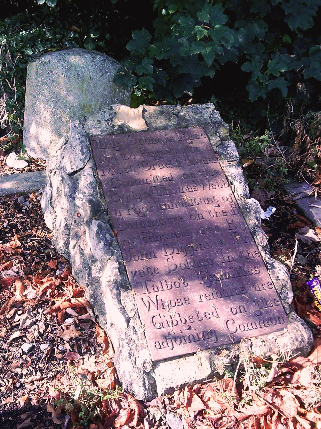
It reads :
This Stone is Erected to Perpetuate a Most Cruel Murder Commited on the Body of Thomas Webb a Poor Inhabitant of Swanmore on the 11th of February 1800 By John Diggins a Private Soldier in the Talbot Fencibles Whose remains are Gibbited on the adjoining Common
The Talbot – or Tarbet – Fencibles were barracked in Botley at the time. Private Diggins, with two other soldiers, had come upon Thomas Webb, a poor and elderly pedlar, somewhere near Kings Corner (Pinkmead) in Curdridge. They not only robbed him of what few shillings he had, but then – according to a contemporary newspaper report – stabbed him, threw him in a ditch and stamped on him. Despite his injuries, Webb was able to crawl to a nearby cottage and get help – including the removal from his body of six inches of bayonet by a local surgeon. He was also able to tell what had happened – before he died. Diggins was found guilty of the murder at Winchester Assizes and sentenced to be hanged. The other two soldiers were acquitted for lack of evidence. Diggins was hanged in Winchester and his body then gibbited – that is, hung to rot – on Curdridge Common, between the main road to Shedfield and Outlands Lane. Thomas Webb was buried in St Peter’s Church graveyard, Bishops Waltham.
Meanwhile, the stone referred to on the plaque is not the cemented stones on which the plaque itself is mounted, but the undistinguished stone, without inscription, which sits half buried behind it. This suggests that the plaque was a later addition, Victorian perhaps, by when local history had became a subject of much interest.
All this can be found in more detail in local historian Dennis Stokes’ Botley and Curdridge – A history of two Hampshire villages, published by the Botley and Curdridge Local History Society (2007) – http://www.botley.com/history-society
I became curious about the plaque when I came upon the following:
Hampshire Treasures, Volume 1 ( Winchester City District), Page 82 – Curdridge
| Memorial Stone | Site of murder. Culprit hanged on local gibbet, cast iron plaque removed to Portsmouth City Museum. | SU 520 130 1904 27 |
(http://www.hants.gov.uk/hampshiretreasures/vol01/page082.html )
How can the plaque have been ‘removed’ to Portsmouth and yet still be present in Curdridge ?
I wrote to the Museum about it. Their reply was :
“The original plaque was donated to the Portsmouth City Museum before 1945 & is kept in storage there, although it has been used in a display at Southsea Castle. The plaque at Botley Station, therefore, must be a copy.”
Our plaque a copy ? Why, that practically makes it a forgery !
Or, perhaps, for some reason, two copies of the plaque were made at the same time? But why ?
History, it seems, is full of mystery . . .
Still, if anyone knows anything more about this matter, do let me know.
*
And yet another :
The Cruise of the Land-Yacht “Wanderer”; or Thirteen Hundred Miles In My Caravan, by William Gordon Stables, London 1892.
Extract from Chapter Twenty Seven.
Botley is one of the quietest, quaintest, and most unsophisticated wee villages ever the Wanderer rolled into . . . My attention was attracted to a large iron-lettered slab that hangs on the wall of the coffee-room of the Dolphin. The following is the inscription thereon:—
This Stone is Erected To Perpetuate a
Most Cruel Murder Committed on the Body
of Thos. Webb a Poor Inhabitant of Swanmore
on the 11th of Feb. 1800 by John Diggins
a Private Soldier in the Talbot Fencibles
Whose Remains are Gibbeted on the Adjoining Common.
And there doubtless John Diggins‟ body swung, and there his bones bleached and rattled till they fell asunder.
But the strange part of the story now has to be told; they had hanged the wrong man!
It is an ugly story altogether. Thus: two men (Fencibles) were drinking at a public-house, and going homewards late made a vow to murder the first man they met. Cruelly did they keep this vow, for an old man they encountered was at once put to the bayonet. Before going away from the body, however, the soldier who had done the deed managed to exchange bayonets with Diggins. The blood-stained instrument was therefore found in his scabbard, and he was tried and hanged. The real murderer confessed his crime twenty-one years afterwards, when on his deathbed.
So much for the Botley of long ago.
The iron slab, by the way, was found in the cellar of the Dolphin, and the flag of the Talbot Fencibles, strange to say, was found in the roof.